CRUISE MAP


View Cruise Destinations in a larger map

Friday 29 June 2012

Tallinn - Estonia

Welcome back! Today, I want to show you a little of Tallinn, Estonia. Before visiting I could not point to Estonia on a map, but it turned out to be one of my favourite ports!

Untitled
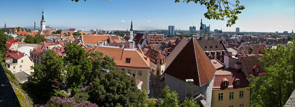
Above: Lower Town of Tallinn with modern skyscrapers in the distance.

Estonia is a country in the Baltic region of Northern Europe and its capital, Tallinn is situated on the northern coast of the country, on the shore of the Gulf of Finland, south of Helsinki, east of Stockholm and west of Saint Petersburg. The Estonians are a Finnic people, and the official language, Estonian, is closely related to Finnish.

Untitled
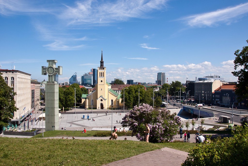
Above: A square in the more modern part of downtown Tallinn.

The country was occupied by both Soviet and Nazi forces during the Second World War. During Soviet rule after the War, more than 20,000 Estonians were forcibly deported either to labour camps or Siberia.

Untitled
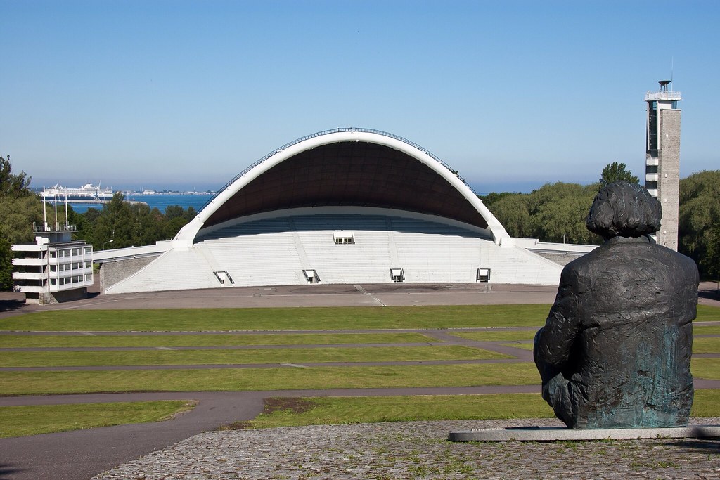
Above: Tallinn Song Festival Grounds (see below).

In 1989, during the 'Singing Revolution', in a landmark demonstration for more independence, a human chain of more than two million people was formed, stretching through Lithuania, Latvia and Estonia. Estonian Song Festivals which began in 1869 and are held in the Tallinn Song Festival Grounds, hold a particular significance now following that peaceful protest for independence.

Untitled
Above: The view from the city wall with the Baltic sea in the distance.

Estonia's formal independence was declared on 20 August 1991, reconstituting the pre-1940 state. The Soviet Union recognised the independence of Estonia on 6 September 1991 and the last Russian troops left on 31 August 1994. If you have time I would strongly urge you to read more about Estonia's 20th Century history - it is fascinating and heartbreaking.

Untitled 
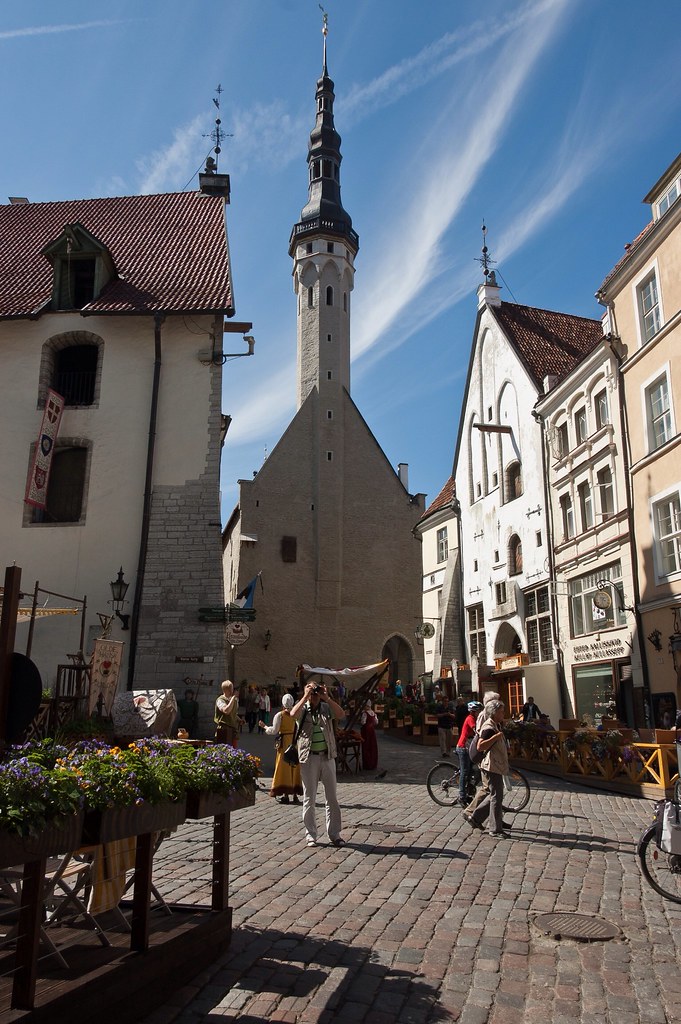
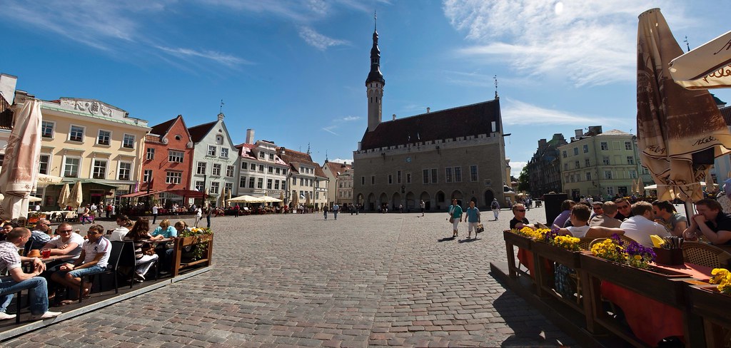
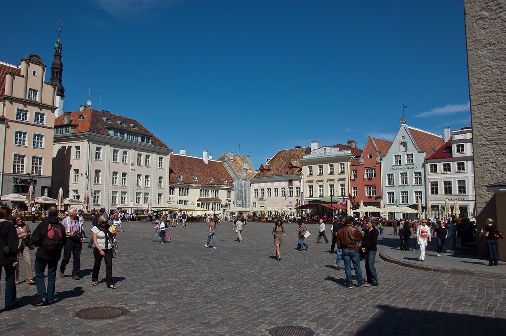
Above: Raekoja plats (Town Hall square), in Tallinn's historic Lower Town.

Since its return to independence, improving air and sea transport links with Western Europe and Estonia's accession to the European Union in 2004 have made Tallinn easily accessible to tourists. Tallinn's Old Town is in the list of UNESCO World Heritage Sites and is the oldest capital city in Northern Europe. The city was known as Reval from the 13th century until the 1920s.

Untitled 
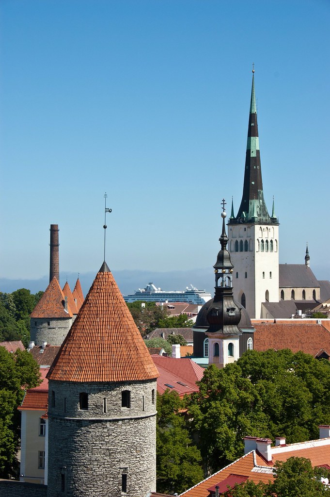
Above: The city wall, the Ryndam and St. Olaf's church - the tallest building in the world from 1549 to 1625.

Tallinn's main attractions are in the two old towns (Lower Town and Toompea) which are both easily explored on foot. Toompea – Upper Town - was once a separate town, the residence of the Chivalry of Estonia, Roman Catholic bishops (until 1561) and Lutheran superintendents of Estonia, occupying an easily defensible site overlooking the surrounding districts.

Untitled 
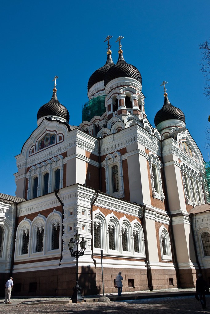
Above: Alexander Nevsky Cathedral built in 1894–1900.

One of the major attractions here is the Russian Orthodox Alexander Nevsky Cathedral, built during the period of Russian Empire. The Cathedral was built on a site that formerly housed a statue of Martin Luther.
Untitled 
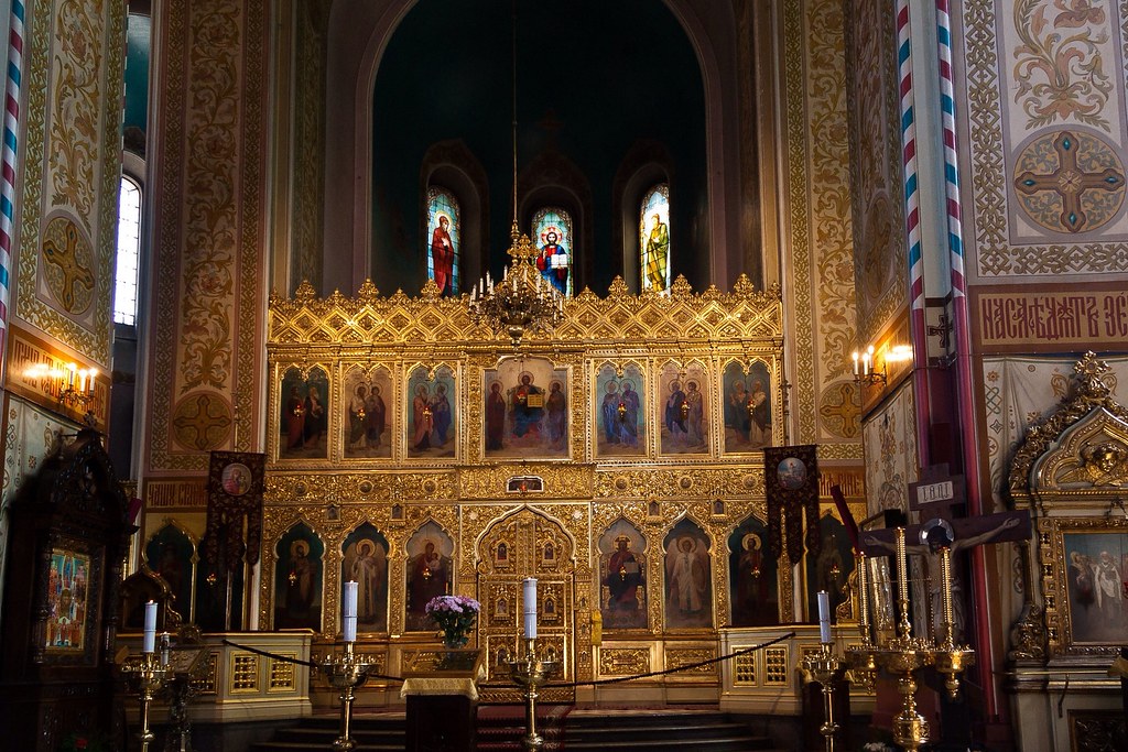
Above: Inside the Alexander Nevsky Cathedral.

The Estonian government is also based in this part of town, just opposite the Cathedral.

Untitled 
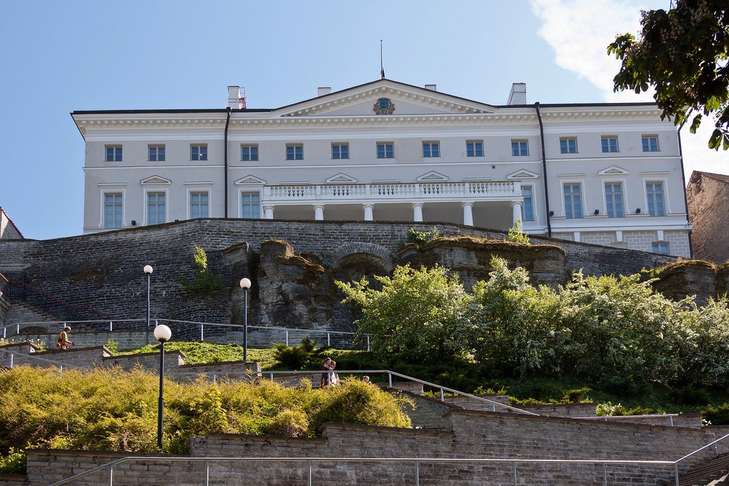
Above: The Stenbock House – Residence of the Estonian government on Toompea hill.

The Lower Town (known as All-linn) is one of the best preserved old towns in Europe and the authorities are continuing its rehabilitation. Major sights include Raekoja plats (Town Hall square), the town walls and towers (notably "Fat Margaret" and "Kiek in de Kök") and the St Olaf Church tower.

Untitled Above: One of the many streets leading off from the Town Hall Square, with the Town Hall centre.

Wandering around the streets was like strolling through Disneyland, except that everything was real! Tourism is big business here and restaurants and cafes had servers dressed in Medieval costume, in an effort to grab your attention.

Untitled Above: Town Hall Square, lined with restaurants on all sides.

I will leave you with a final shot of the city wall that circles old Tallinn. This was an amazing port, and one I would consider visiting again on holiday! I'll be bringing you more Baltic destinations soon.

Untitled 
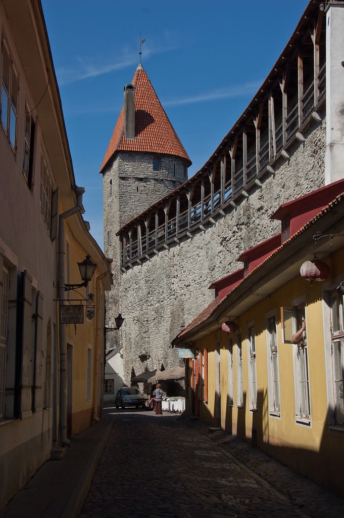
Above: The city wall.

Friday 22 June 2012

North Cape and Molde - Norway

Today I want to take you to two destinations in Norway: North Cape and Molde.

The North Cape is a peninsula on the island of Magerøya in Northern Norway and it is the point where the Norwegian Sea, part of the Atlantic Ocean, meets the Barents Sea, part of the Arctic Ocean. Its 307 metres high, steep cliff is often referred to as the northernmost point of Europe, 1,306 miles from the North Pole.

Untitled
Above: North Cape.

The North Cape was named by English explorer Richard Chancellor in 1553 when he passed the cape in the search for a Northeast passage. A road was opened to the North Cape in 1956 and today, the North Cape is a major tourist attraction with Nordkapphallen, an extensive commercial tourist centre housing a number of exhibits on the Cape's history.

Untitled
Above: In front of the North Cape Globe.

The midnight sun can be seen at North Cape from 14 May to the 31st of July. This is where there are 24 hours of daylight; the sun never actually sets! It was a very strange experience taking a midnight stroll around the outside decks of the Ryndam in daylight!

Untitled
Above: A traditional Sami Camp set up for tourists on their way to North Cape.

The weather during our visit was very windy and wet. So windy in fact, that on the cliff at North Cape I could actually lean into the wind!

Untitled
Above: Nice day for a picnic beside the frozen lake!

Our ship docked at Honningsvåg for the trip to North Cape. The city claims to be the northernmost one in Norway and even in the world.

Untitled
Above: Honningsvåg from our ship.

However, thanks to the Gulf Stream, it has a subarctic climate and an ice-free ocean which provides rich fishing. Even at 71°N, many private gardens in Honningsvåg have trees, although rarely more than 3 – 4 metres tall.

Untitled
Above: Buses line up at Honningsvåg to take passengers to North Cape.

Our next destination is Molde - Norway, an old settlement which emerged as a trading post in the late Middle Ages. The town continued to grow throughout the 18th and 19th centuries, becoming a centre for Norwegian textile and garment industry, as well as the administrative centre for the region, and a major tourist destination.

Untitled Above: The town of Molde.

The Moldejazz jazz festival is held in Molde every July. Moldejazz is the largest and oldest jazz festival in Europe, and one of the most important. An estimated 40,000 tickets are sold for the more than a hundred events during the festival. Between 80,000 and 100,000 visitors visit the city during the one-week long festival.

Untitled
Above: A boat docked in the harbour of Molde.

The panoramic view of some 222 partly snow-clad peaks, often called the Molde panorama, is famous, having been one of the attractions drawing tourists to the town in the 19th century.

Untitled
Above: Kayakers with the Molde panorama in the background.

I will leave you with a shot of almost the entire Molde panorama. It is very impressive in person, and I would recommend you click on the photo for a larger view! Until next time.

Untitled

Tuesday 19 June 2012

Geiranger, Norway

Welcome back to my blog! For the last 6 weeks or so, I have had the pleasure of exploring the country of Norway. Today I want to show you Geiranger and Geiranger Fjord, home to some of the most spectacular scenery in the world; the area has been named the best travel destination in Scandinavia by Lonely Planet.

Untitled
Above: The view of Geiranger Village and Geiranger Fjord from the famous Flydal viewpoint.

Norway has a total area of 148,747 square miles and a population of about 5 million (it is the second least densely populated country in Europe). The majority of the country shares a border to the east with Sweden and its extensive coastline, facing the North Atlantic Ocean, is home to its famous fjords.

Untitled
Above: Geiranger Fjord.

Geiranger Fjord is Norway's most famous fjord, shaped like an S, 16km long and up to 250 metres deep with several beautiful waterfalls such as The Seven Sisters, The Bride's Veil and The Suitor.

Untitled
Above: A panoramic view of Geiranger Fjord, with the village to the left and the Ryndam in the centre.

Geirangerfjord is a branch of a greater fjord - Storfjord - that starts south of Alesund, narrowing as it winds its way inland between mountains rising ever higher.

Untitled
Above: The Ryndam anchors in the bay and we use our lifeboats to reach the shore. This is because there is no dock big enough for cruise ships at Geiranger!

The landscape of the Fjord is very dramatic with mountain farms perched on ledges along the route. The area was added to UNESCO's World Heritage List in 2005.

Untitled
Above: Geiranger church in the centre of the village, built in 1842.

The third biggest cruise ship port in Norway, the small tourist village of Geiranger receives 140 to 180 ships during the four-month tourist season. Several hundred thousand people pass through every summer, and tourism is the main business for the 250 people who live there permanently. There are five hotels and over ten camping sites.

Untitled
Above: The view from Vesterås Farm, with the village nestled in the valley below. Many popular walks begin here.

Geiranger is under constant threat from the mountain Åkerneset which could erode into the fjord. A collapse could cause a tsunami that could destroy downtown Geiranger.

Untitled
Above: Goats at Vesterås Farm. There were also sheep (with bells) and even lamas!

One of the most popular walks is a hike to Storseterfossen (Storseter Waterfall), where you can actually walk behind the waterfall.

Untitled
Above: Storseter Waterfall.

Untitled
Above: The view from beside the waterfall.

Geiranger is one of the most beautiful places I have seen in Norway but there many other fantastic ports that I will be sharing with you in the coming weeks. Thanks for reading!

Friday 8 June 2012

Rotterdam, The Netherlands

Hello again! Today I thought I would give you a brief glimpse of Rotterdam, the second largest city in the Netherlands and our home port for the first couple of cruises. Rotterdam is known for its university (Erasmus), its cutting-edge architecture, its lively cultural life and its maritime heritage.

Untitled
Above: City Hall which survived the Blitz on May 14, 1940.

Starting as a dam constructed in 1270 on the Rotte River, Rotterdam has grown into a major international commercial centre. Its strategic location at the Rhine-Meuse-Scheldt delta on the North Sea and at the heart of a massive rail, road, air and inland waterway distribution system extending throughout Europe is the reason that Rotterdam is often called the "Gateway to Europe".

Untitled
Above: The original headquarters of Holland America Line! The Ryndam docked right next to it.

The largest port in Europe and still one of the busiest ports in the world, the port of Rotterdam was the world's busiest port from 1962 to 2004, at which point it was surpassed by Shanghai. Rotterdam is divided into a northern and a southern part by the river Nieuwe Maas with the city centre located on the northern bank.

Untitled
Above: Dry docks (where ships are serviced) in the port of Rotterdam.

During World War II, the German army invaded the Netherlands on May 10, 1940. Although Hitler was met by fierce resistance, the Dutch army was finally forced to surrender on May 15, 1940, following Hitler's bombing of Rotterdam on May 14 and his threat to bomb other Dutch cities. The heart of Rotterdam was almost completely destroyed by the Luftwaffe; 900 civilians were killed and 80,000 made homeless.

Untitled
Above: Holland America's old Rotterdam ship which is now a floating conference centre.

The self-image of the city is that of a no-nonsense workers' city. In that sense, there is a healthy competition with Amsterdam, which is often viewed as the cultural capital of the Netherlands. There is a saying: "Amsterdam to party, Den Haag (The Hague) to live, Rotterdam to work". Another one, more popular by Rotterdammers, is "Money is earned in Rotterdam, divided in The Hague and spent in Amsterdam". Another saying that reflects both the rivalry between Rotterdam and Amsterdam is "Amsterdam has it, Rotterdam doesn't need it".

Untitled
Above: The Cube Houses - crazy architecture! The building is now a Youth Hostel - nobody wanted to live in them permanently!

The city also houses the 186 metres tall Euromast, which has long been a major tourist attraction. It was built in 1960, initially reaching a height of 101 metres; in 1970, the Euromast was extended by 85 metres to its current height.

Untitled
Above: The Euromast. We saw somebody abseiling off it!

Next time, we're headed off to Norway to see some of the spectacular scenery and ports of call!

Monday 4 June 2012

Casablanca, Morocco.

Welcome back! Today, I'm excited to share my day in Casablanca, Morocco with you; it was a unique experience!

Untitled
Above: Hasan II Mosque and courtyard, located on the coast of Casablanca.

Morocco is a country located in North Africa, part of the Maghreb region, in addition to Tunisia, Algeria, Mauritania, and Libya, with which it shares cultural, historical and linguistic ties. Morocco gained independence from France on March 2, 1956 and the city of Casablanca is now developing a tourism industry.

Untitled
Above: A street (not atypical!) in Casablanca.

Casablanca is in western Morocco, located on the Atlantic Ocean and is Morocco's largest city as well as its chief port. Casablanca is considered the economic and business centre of Morocco, while the political capital city of Morocco is Rabat.

Untitled
Above: Looking down the Boulevard de Paris in central Casablanca.

The city combines Hispano-Mauresque and Art Deco architectural styles, and is dotted with markets, street vendors and dusty streets. We explored the city in a large group which worked out well as I would have felt lost and a little intimidated on my own!

Untitled
Above: A cafe in one of the market areas.

Almost all Moroccans speak either Berber or Moroccan Arabic as mother tongues. Many Moroccans master both languages at native-speaker level. Some of the locals we talked to also spoke a little French (which was useful), a legacy of the French sovereignty.

Untitled
Above: One of the markets, located in the old Kasbah.

Casablanca is home to the Hassan II Mosque, designed by the French architect Michel Pinseau. Located on the ocean front, the mosque has room for 25,000 worshippers inside, and a further 80,000 can be accommodated in the mosque's courtyard.

Untitled
Above: Visiting the Hassan II Mosque.

The minaret at the Mosque is the world's tallest at 210 metres and the mosque itself is the largest in North Africa, and the third largest in the world.

Untitled
Above: Hassan II Mosque's Minaret, the tallest in the world.

Work on the mosque was started in 1980, and was intended to be completed for the 60th birthday of the former Moroccan king, Hassan II, in 1989. However, the building was not inaugurated until 1993. Authorities spent an estimated $800 million on the construction of the building.

Untitled
Above: The impressive entrance to the Mosque.

Sadly, we did not have time to take a tour inside the Mosque (other than catching a glimpse through a door), but one of the guides was happy to let us wear his fez (for a tip of course):

Untitled
Above: Fezzes are cool.

The Parc de la Ligue Arabe (formally called Lyautey) is the city's largest public park. On its edge is the Casablanca Cathedral (Cathédrale Sacré-Coeur).

Untitled
Above: The Parc de la Ligue Arabe with Casablanca Cathedral in the background.

The Cathedral is longer in use for religious purposes, but it is open for visitors and a splendid example of Mauresque architecture.

Untitled
Above: Casablanca Cathedral.

Untitled
Above: Looking across from the park, towards a government building.

It was an incredible experience walking around the city. Many of the streets were very dirty and unpleasant but there was a real vibrancy and life to the city. Even more so than the Caribbean, this felt like a totally new culture, watching locals walking around in robes and seeing taxi drivers, kneeling by their cars in prayer.

Untitled
Above: Taxi drivers praying.

We will be visiting another city in Morocco, Tangier, in August so I will be sure to bring you photos and stories from there. One of the most impressive things about the city, was the port where we docked. The Port of Casablanca is one of the largest artificial ports in the world, and the largest port of North Africa. It is also the primary naval base for the Royal Moroccan Navy.

Untitled
Above: Leaving the port where we had docked.

I'll leave you with the Moroccan sunset that bade us farewell as we headed for the Spanish coast.

Untitled