The final blog from my Maasdam cruise is here! Today I will show you inside the Maasdam and also give you a chance to listen to my trio album if you have not heard it already!
Much of the Maasdam is identical to the Ryndam so if you want to see more photos check out my Inside the Ryndam blogs here and here from last year.
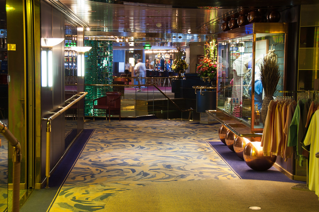
Above: Looking towards the Atrium from the Showroom, located at the front of the ship on Deck 8.
Named for the Maas River in the Netherlands, the ms Maasdam is the fifth ship in Holland America Line's 135-year history to bear the name. At 720-feet, the ms Maasdam is designed to carry fewer guests - 1,258 (580 crew) while providing more space for each person.
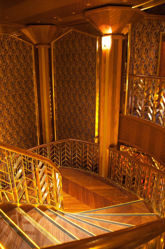
Above: One of the staircases in the showroom.
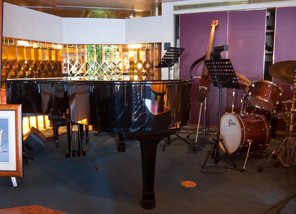
Above: The Ocean Bar bandstand where my trio, The Neptunes perform.
Above: The grill at the rear of the bandstand backs onto the atrium resulting in the disconcerting sensation of passengers watching you (and sometimes speaking to you) from behind.
Featuring an interior motif that pays homage to the historical Dutch East and West India companies of the 17th through 19th centuries, the centrepiece of this ship features Luciano Vistosi's "Totem," a monumental sculpture using nearly 2,000 glimmering pieces of glass, prominently displayed in the three-story atrium.
Above: The atrium of the Maasdam.
If you haven't had a chance to listen to my album recorded on the Zuiderdam in December last year, you can check it out (along with bonus tracks) below. Thanks for reading this blog and I look forward to showing you around the Baltic and the Mediterranean in a few weeks time!
I've finally come to the last blog about the many Caribbean islands I visited on the Maasdam. Today it is the turn of St. Croix and St. Kitts - enjoy!
Above: Frederiksted, the town in St. Croix where our ship docked.
Saint Croix is the largest island in the United States Virgin Islands (USVI), an unincorporated territory of the United States, just like Saint Thomas. Formerly the Danish West Indies, they were sold to the United States by Denmark in the Treaty of the Danish West Indies of 1916, in exchange for a sum of $25million in gold.
Above: A street in Christiansted, the main town in St. Croix.
During my time in St. Croix, I took a walking tour of Christiansted which has preserved the 18th-century Danish-style buildings constructed by African slaves.
Above: The customs house in Christiansted.
Solid stone buildings in pastel colours with bright red tile roofs line the cobblestone sidewalks, adding a touch of European charm.
Above: The restored Government House on King Street, Christiansted.
Fort Christiansvern sits at the edge of the harbour and doubled as a prison for African slaves who were imprisoned in very cramped spaces.
Above: Fort Christiansvern.
Above: Canons running along the top of the Fort.
We'll leave St Croix with a panoramic shot of the harbour area of Christensted.
ST KITTS
Saint Kitts (also known more formally as Saint Christopher Island) is an island in the West Indies. The west side of the island borders the Caribbean Sea, and the eastern coast faces the Atlantic Ocean. Saint Kitts and the neighbouring island of Nevis constitute one country: the Federation of Saint Kitts and Nevis.
Above: A panoramic shot of downtown Basseterre from the ship.
The island is one of the Leeward Islands in the Lesser Antilles and measures 65 square miles. The capital of the two-island nation, and also its largest port, is the town of Basseterre on Saint Kitts where are ship docked.
Above: The two cruise ships docked at the Basseterre port.
For hundreds of years, St. Kitts operated as a sugar monoculture. But due to decreasing profitability, the government closed the industry in 2005. Tourism is a major and growing source of income to the island, although the number and density of resorts is less than on other Caribbean islands.
Above: A 'replica' of Piccadilly circus in downtown Basseterre.
St. Kitts has three distinct groups of volcanic peaks: the North West or Mount Misery Range; the Middle or Verchilds Range and the South East or Olivees Range. The highest peak is Mount Liamuiga, formerly Mount Misery, a dormant volcano some 1,156 m high.
Above: Fountain with Church behind in downtown Basseterre.
On my visit to St. Kitts I did a tour of the island on the narrow gauge St. Kitts Scenic Railway, built in the 1920s to deliver sugar cane and now used as a tourist train.
Above: The St. Kitts Scenic Railway.
The railway hugs the Northeastern coastline and the train rolls across tall steel bridges spanning canyons and winding through small villages and farms. Dark green rainforests are skirted by fields of sugar cane with the volcanic cone of Mt. Liamuiga rising above the railway.
Above: The interior of the train.
Above: One of the villages we saw on the tour.
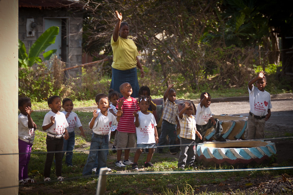
I'll leave you with a lovely shot of some local school kids who came out to greet the train. I hope you have enjoyed visiting these islands with me; I'll be back with a final post exploring inside the Maasdam before embarking on my European cruise next week!
Hello again! Although I'm back from my cruise I still have a few more islands to show you. Today, it's Saint Barthélemy and Saint Thomas!
Above: The main harbour of St. Barts, in the town of Gustavia.
Saint Barthélemy is an overseas collectivity of France just like the island of Martinique which I have previously blogged about. Often abbreviated to St. Barts in English, the indigenous people called the island Ouanalao.
Above: Shell Beach, a short walk from downtown Gustavia.
Above: You can see why it is called Shell Beach!
St. Barts is a small volcanic island fully encircled by shallow reefs, with an area of 13 square miles and a population of 8,823.
Above: A quaint street in the downtown area of Gustavia.
The capital, Gustavia contains the main harbour to the island and interestingly, St. Barts is the only Caribbean island which was a Swedish colony for any significant length of time.
Above: An old fort which sits at the edge of the harbour.
The language, cuisine and culture are distinctly French and the island is a popular tourist destination during the winter holiday season, especially with the rich and famous during the Christmas and New Year period.
During my brief time in St. Barts I took a speedboat ride around the island which took in a number of beautiful bays as well as a look at the airport.
Above: The speedboat - no seats, just restraints to lean against!
The runway ranked 3rd in the History Channel's 'Most Extreme Airports' show. The arrival descent is extremely steep over the hilltop traffic circle and departing planes fly right over the heads of sunbathers. This is a video from YouTube which demonstrates just how tricky it is to land!
ST THOMAS
Let's move on to Saint Thomas now. Along with the islands of Saint John, Saint Croix, and Water Island, St.Thomas is a county and constituent district of the United States Virgin Islands (USVI), an unincorporated territory of the United States.
Above: Spot my ship! A panoramic view over part of Charlotte Amalie port.
The territorial capital and main port is called Charlotte Amalie and the island has a population of 51,000 with a land area of about 31 square miles.
Above: An iguana sunning itself by our ship.
The Dutch West India Company established a post on Saint Thomas in 1657 but in 1666 the Danish conquered the island, and by 1672 had established control over the entire island through the Danish West India and Guinea Company.
Above: Magens Bay, located on the Atlantic side of St. Thomas.
In 1917 St. Thomas was purchased (along with Saint John and Saint Croix) by the United States for $25 million in gold, as part of a defensive strategy to maintain control over the Caribbean and the Panama Canal during the First World War.
Above: One of the many tourist buses at the Mountain Top Resort, home of the Banana Daiquiri (a banana and rum drink).
After the First World War tourism to the island began to increase. With relatively cheap air travel and the American embargo on Cuba, the number of visitors grew.
Above: A panorama of downtown Charlotte Amalie with more cruise ships docked to the left. Click here for a much bigger view!
Despite natural disasters such as Hurricane Hugo (1989) and Hurricanes Luis and Marilyn (1995), the island's infrastructure continues to improve as the flow of visitors continues. One of the most popular tourist spots is Paradise Point, a small resort located on a hilltop above downtown Charlotte Amalie.
Above: The 'SkyRide' that takes visitors to the top!
The view is quite spectacular so I'll leave you with a final shot of downtown Charlotte Amalie: